Key points
- Researchers analyzed Landsat imagery from 1984 to 2023 to track mangrove extent and canopy density worldwide.
- Mangroves lost nearly 3,000 square kilometers between 1984 and 2010, then gained nearly 2,000 square kilometers afterward.
- About two-thirds of the expansion came from new areas and one-third from regrowth in degraded forests.
- Burma's mangrove cover shrank 28.6 percent from the 1980s to 2010 but has grown about 10 percent since.
For decades, satellite records mostly showed mangrove forests shrinking. A study published in Science now suggests the world's mangroves started recovering around 2010. Using Landsat imagery collected from 1984 to 2023, the researchers measured how much ground mangroves covered and how dense their canopies were. According to NASA Earth Observatory, they counted losses of nearly 3,000 square kilometers (1,200 square miles) from 1984 to 2010, followed by a gain of nearly 2,000 square kilometers (770 square miles) after 2010.
Growth in Asia, Australia and South America led the rebound. Zhen Zhang, an environmental scientist at Tulane University, says roughly two-thirds of the added forest came from mangroves moving into new ground, and the remaining third from regrowth in degraded stands. Many forests also have thicker, more closed canopies than in 2010, a sign of healthier forests, particularly in South America.
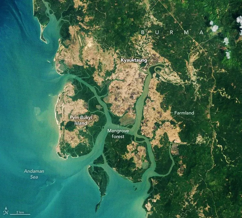
Burma (Myanmar) shows the shift clearly. Mangroves there disappeared quickly during the 1980s and 1990s as farming, aquaculture and firewood harvesting spread along the coast. Overall, the country's mangrove cover shrank by 28.6 percent between the 1980s and 2010, then grew about 10 percent afterward. The authors credit restoration and greater awareness after the 2004 Indian Ocean tsunami, stronger legal protection for forests, and heavy sediment deposits that formed fresh mudflats. New mudflats near the Amazon's mouth and in northern Australia also let mangroves spread, while warmer temperatures and fewer freezes pushed them into colder places such as the southeastern U.S.
Not every region gained. Heavy losses in the Niger Delta have reduced mangrove area in West and Central Africa since 2010, and tropical cyclones degraded wide areas in North America and southern Africa. Zhang cautions that the recent global gains are no reason for complacency.
Why it matters
Mangrove ecosystems can store up to four times as much carbon as taller inland tropical forests, shield coasts from erosion and storm surges, and serve as nurseries for fish, shrimp and crabs.
What we don't know yet
Losses still outweigh gains in some places. Mangrove area in West and Central Africa has fallen since 2010, cyclones have degraded mangroves in North America and southern Africa, and deforestation is still a common problem in Burma.
Terms in this story
- Mangroves
- Salt-tolerant trees that grow along tropical and subtropical coastlines, often on stilt-like roots.
- Canopy
- The upper layer of a forest formed by the trees' leaves and branches.
- Landsat
- A series of Earth-observing satellites whose imagery has been used to map mangrove forests since the 1970s.
Sources and verification
DexScience articles are produced with AI assistance and an automated fact-check against the linked sources. Spotted an error? Tell us and we will correct it openly.