Key points
- NASA researchers produced consistent 3D topography maps covering all of California, detailed enough to resolve a single tree.
- The statewide map has a pixel size of one square meter, about 1.2 square yards.
- Most space-based lidar data resolve 10 to 25 square meters per pixel, according to NASA.
- The team, which works with two California state agencies, hopes to build wildfire risk products from the maps.
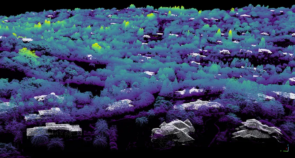
NASA scientists have built one consistent set of 3D topography maps covering all of California. The agency reports that the maps are detailed enough to pick out individual trees. The work comes from NASA's Wildfire, Ecosystem Resilience, and Risk Assessment Initiative, and the team hopes to use the maps in tools that judge wildfire risk across the state.
The maps rely on airborne lidar, short for light detection and ranging. A lidar instrument fires laser pulses and times how long they take to bounce back. Those timings give distances that can be assembled into a three-dimensional picture of the ground and everything standing on it. The researchers drew on lidar data gathered by the U.S. Geological Survey's 3D Elevation Program and turned it into a statewide product in which each pixel covers one square meter (about 1.2 square yards).
According to NASA, that is much finer than most lidar collected from orbit, which typically resolves 10 to 25 square meters per pixel. Scientists already use the technique to chart forests and cities, and even planets and moons far from Earth.
The NASA team is working with the California Natural Resources Agency and the California Air Resources Board. Together they hope to use the maps to develop products for assessing wildfire risk, protecting wildlife and ecosystems, and managing natural resources throughout the state. NASA has made the lidar dataset available to view online.
Why it matters
A single, high-resolution 3D map of the whole state could give California a common foundation for building tools to assess wildfire risk, protect ecosystems and manage natural resources.
What we don't know yet
The wildfire risk, wildlife and resource management products are still a goal. NASA says the team hopes to develop them from the maps but has not yet described any finished tools.
Terms in this story
- Lidar
- A remote-sensing method that measures distances by timing how long laser pulses take to reflect back from surfaces.
- Topography
- The shape and height of the land surface, along with features such as vegetation and buildings that stand on it.
- Pixel size
- The area on the ground represented by a single cell of a digital map, which sets how much detail the map can show.
Sources and verification
DexScience articles are produced with AI assistance and an automated fact-check against the linked sources. Spotted an error? Tell us and we will correct it openly.